

Are you ready to embrace the technology change in Mines? Let's explore the various applications of drone survey with Deepak Gaur who is founder of Mining 360 Services explained during a webinar held on the 25th day of April 2020.
He showed the actual process adopted to get the drone survey done in one of the open cast mine through a case study done by Mr. Amresh Samantaray, who is Director of GEOID Resources Pvt Ltd.
Evolution in Survey Field
|
B.C. Surveying
Tools: |
•
Egyptians in 1400 B.C. were the first surveyors documenting
their techniques. •
The tools were sighting and leveling instruments,
ropes, and plumb bobs. •
Nearly a thousand years later, magnets were used in China to determine the direction, a predecessor to modern compasses. •
The diopter soon became the instrument of choice
for surveyors after the development of geometry. |
|
Inventions
of 18th Century: |
•
Devices
based on the Cross-Staffs and the
production of quadrants became
refined, sextants, pentants, and
octants were developed to enhance
accuracy and ease of use. •
Prior
to the turn of the century, the theodolite was developed and systematically altered surveying, as it played an integral role in triangulation. |
|
Surveying Blossoms in the 19th Century: |
•
Devices
such as alidade, The Transit designed by William Young (1830) was invented. • At the same time, Australians created Gunter’s chain and the steel measuring band to perfect surveying techniques. |
|
Surveying thrived in 20th Century |
•
Gunter’s
chain was replaced by steel bands and invar tapes, and later by Electromagnetic Distance Measurement (EDM)
equipment and subsequently Global
Positioning System (GPS) devices. •
Likewise,
compasses were replaced by transits, later theodolites and then Total Stations, which combined angular and
distance measurement in a single survey instrument. |
|
21st Century will bring Paradigm Shift in Surveying |
•
Laser
Scanners, Robotic LIDAR Scanners, Drone (UAV) Surveying……… |
What is meant by drone survey?
Drone surveys are a faster, safer and more cost-efficient way to survey at
height. Sometimes referred to as aerial
surveys, UAS (Unmanned Aerial System) surveys, or UAV (Unmanned Aerial
Vehicle) surveys, drone surveys
are an increasingly popular method of
surveying form the air.
To Produce useful and accurate 3D Drone Data, three ingredients are essentials:
Good Ground
Control Points.
The Science
of Photogrammetry.
Clear Aerial Drone Imaginary.
How Drone Photos
turned into 3D survey?
The best way to visualize this is to use your eyes—literally. Your eyeballs
are using photogrammetry all the time.You have two eyes (two cameras), processing
a live feed of your surroundings. Because your eyes are slightly apart, you’re
getting two different inputs at slightly different angles.
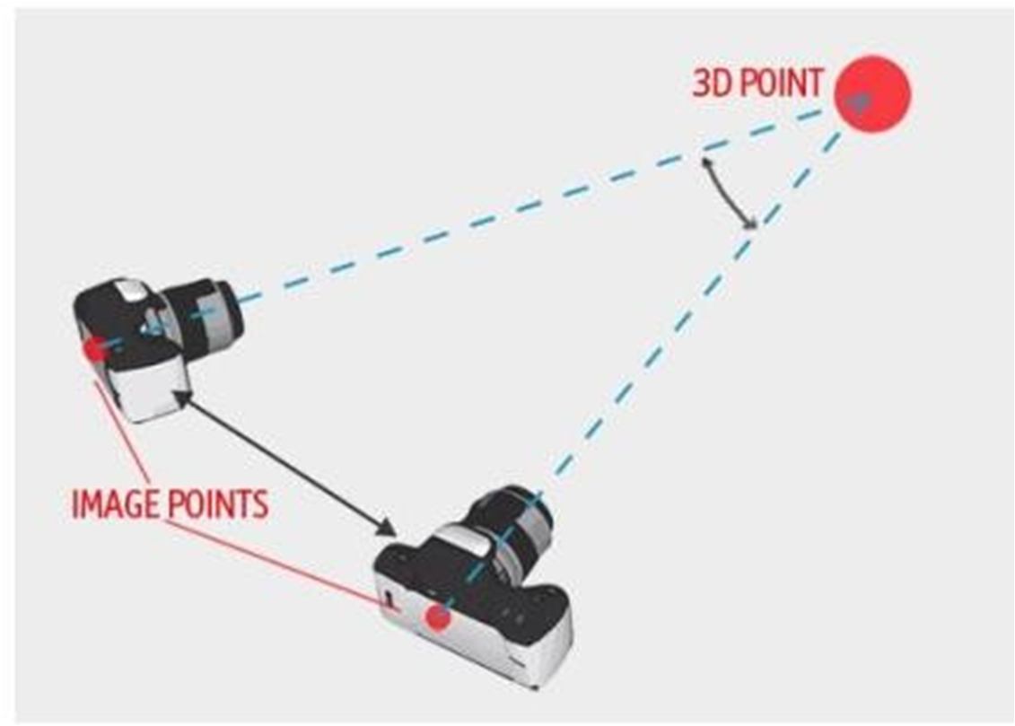
Your mind is rendering a live depth map of the 3D world from two 2D inputs—just
like how Propeller renders a 3D survey from many 2D photos.
Application of
Drone Survey Data?
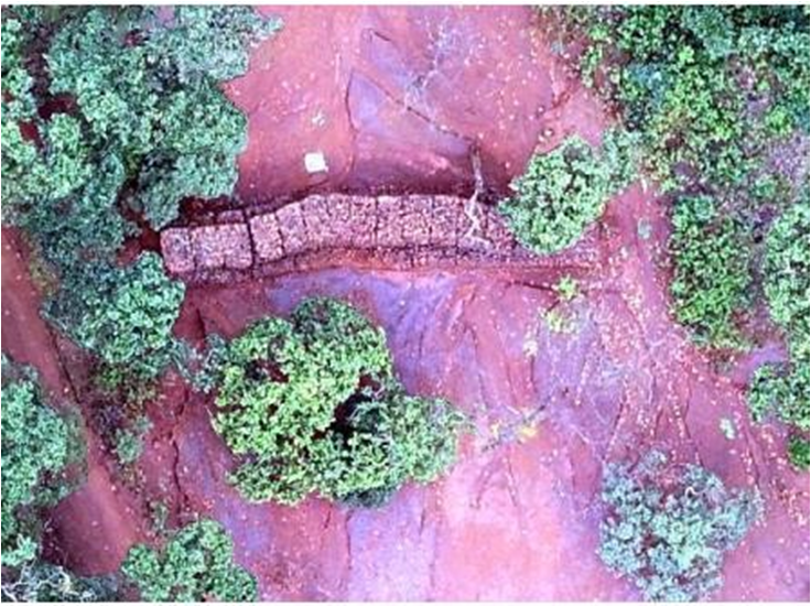
CONTOURING OF THE
M.L. AREA:
Contours
can be generated throughout the mining lease area at any specific interval from 0.1 m to 0.5m, contour lines can be
generated for depth analysis.
 |
| Contours super-imposed on the 3 D image given by Drone |
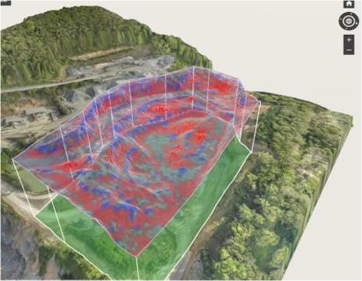
Monitoring
the Actual Development with respect to the Proposed Development Plan:
 |
Year-wise development plan on the 3 D image |
Stock-Pile Management:
Stockpile management is perhaps the most widely used worksite application for drones, and for good reason: drones have completely transformed this common workflow.
 |
Section profile superimposed with initial position |
Quarry Volume Excavation Calculations:
Facilitates site managers to check monthly pit volumes and compare the current surface against previous datasets.


Quarry and dump slope monitoring:
Drone data provides an accurate and up-to-date
visualization of worksites allowing for better pit and dump design and
management. With regular flights, sites can build up a visual record of changes over time, allowing site managers to check weekly/monthly pit volumes and
compare the current surface against previous datasets.

Inspection:
Drone survey helps environmental departments ensure that site boundaries are preserved and protected areas are not disturbed. Photo Pane view helps geologists perform accurate Geotech mapping and bench face inspections, and assists in the close monitoring of the fixed plant.


Haul road analytics overlaid:


Quarry & Blasting :
Any blast area can be easily and inexpensively surveyed with a drone.Geoid processes the raw data, and presents it as accurate 3D models, Orthophoto and digital point clouds, allowing for easy drill depth calculations and further analysis.


Surface run-off management and Monitoring of other Environment Protection Measures:
Garland drain, Retaining Wall, Check dams, Check Wires, Settling ponds, Contour trench, Monitoring Stations, etc. can be checked as per proposed v/s actual
Safety Aspects in mines :
The
output generated from drone survey can help in analyzing and easily
finding out the major safety aspects
like
Bench
height & width,
Haul
Road Parameter such as Gradient & Width,
Road
curves
Road
Conditions,
Pre
Blast & Post Blast rock thrown analysis & Muck-Pile analysis
Slope
stability of bench & dumps
Traffic
Management
Power
line Mapping
Water-shed
analysis
Security:
The
output generated from drone survey can help in analyzing and easily finding out the major security aspects
Surveillance
of Mine Site
Motion
Tagging & Tracking of animals
Tree
Monitoring
By
acquiring regular aerial survey data the mining operation can
Ensure
environmental compliance with local regulations.
Land
use can be monitored and any encroachment on company
Property
quickly detected.
Crushing, Screening Plant, Ore movement etc:
Effective
planning of crushing, screening Plant.
Calculation of lead distance & traffic route management
Effectively
grade control through blending
of various quality from different locations
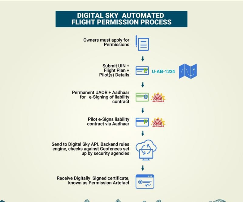
Legal Aspect of flying Drone in India ( Digital Sky platform)

Conclusion:
Drones are becoming
an integral tool in this transformation, replacing manual inspections in the
most hazardous areas and collecting critical information, while drastically
reducing the time and manpower required.
It provides technological
solutions to increase efficiency, improve safety and streamline
operations.
Thanks for reading
my article! Now I’d love to hear from you. What is the advantage of using Drone
over the conventional method of surveying in mines and also tell me some cheap
drones used for surveying in mines? Do you have any questions application of
Drone Technology in opencast mining? Drop me a line in the comments and I’ll
get back to you straight away
KnowledgeIQ is now on Telegram. Click here to join our channel and stay updated with the latest Mining news and job updates.
Like us on Facebook and follow us on Twitter.
I am technologist who is passionately dedicated to bring a single platform of knowledge to a mining and geology enthusiast to transform him to a tomorrow's Global leader. This blog provide you with online study material to clear your concepts in various mining technologies and all news/notification related to Earthscience industries.
1 comments:
Click here for commentsGood
ConversionConversion EmoticonEmoticon